

0
Owner's of the Garmin GPS Receiver Garmin 18X GPS Receiver Module gave it a score of 0 out of 5. Here's how the scores stacked up:
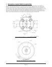
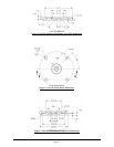


190-00879-08 GPS 18x Technical Specifications Rev. D
Page 17
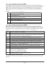
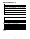
4.2.4 Global Positioning System Fix Data (GGA)
$GPGGA,<1>,<2>,<3>,<4>,<5>,<6>,<7>,<8>,<9>,M,<10>,M,<11>,<12>*hh<CR><LF>
<1>
UTC time of position fix, hhmmss format for GPS 18x PC or LVC; hhmmss.s format for GPS
18x-5Hz
<2> Latitude, ddmm.mmmm format for GPS 18x PC/LVC; ddmm.mmmmm for GPS 18x-5Hz
(leading zeros will be transmitted)
<3> Latitude hemisphere, N or S
<4> Longitude, dddmm.mmmm format for GPS 18x PC/LVC; dddmm.mmmmm for GPS 18x-5Hz
(leading zeros will be transmitted)
<5>
Longitude hemisphere, E or W
<6> GPS quality indication, 0 = fix not available, 1 = Non-differential GPS fix available, 2 =
Differential GPS (WAAS) fix available, 6 = Estimated
<7> Number of satellites in use, 00 to 12 (leading zeros will be transmitted)
<8> Horizontal dilution of precision, 0.5 to 99.9
<9> Antenna height above/below mean sea level, -9999.9 to 99999.9 meters
<10> Geoidal height, -999.9 to 9999.9 meters
<11> Null (Differential GPS)
<12> Null (Differential Reference Station ID)
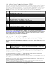
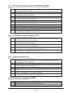
4.2.5 GPS DOP and Active Satellites (GSA)
$GPGSA,<1>,<2>,<3>,<3>,<3>,<3>,<3>,<3>,<3>,<3>,<3>,<3>,<3>,<3>,<4>,<5>,<6>*hh<CR><LF>
<1> Mode, M = Manual, A = Automatic
<2> Fix type, 1 = not available, 2 = 2D, 3 = 3D
<3> PRN number, 01 to 32, of satellite used in solution, up to 12 transmitted (leading zeros will be
transmitted)
<4>
Position dilution of precision, 0.5 to 99.9
<5>
Horizontal dilution of precision, 0.5 to 99.9
<6>
Vertical dilution of precision, 0.5 to 99.9
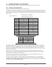
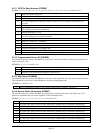
4.2.6 GPS Satellites in View (GSV)
$GPGSV,<1>,<2>,<3>,<4>,<5>,<6>,<7>,...<4>,<5>,<6>,<7>*hh<CR><LF>
<1>
Total number of GSV sentences to be transmitted
<2> Number of current GSV sentence
<3>
Total number of satellites in view, 00 to 12 (leading zeros will be transmitted)
<4>
Satellite PRN number, 01 to 32 (leading zeros will be transmitted)
<5> Satellite elevation, 00 to 90 degrees (leading zeros will be transmitted)
<6>
Satellite azimuth, 000 to 359 degrees, true (leading zeros will be transmitted)
<7>
Signal to noise ratio (C/No) 00 to 99 dB (leading zeros will be transmitted)
Note: Items <4>,<5>,<6>, and <7> repeat for each satellite in view to a maximum of four (4) satellites per sentence.
Additional satellites in view information must be sent in subsequent bursts of NMEA 0183 data. These fields will be
null if unused.


Find Your Products By Category
- Photography
- Video Game
- Computer Equipment
- TV and Video
- Communications
- Automotive
- Portable Media
- Marine Equipment
- Cell Phone
- Baby
- Home Audio
- Fitness & Sports
- Power Tools
- Household Appliance
- Car Audio and Video
- Personal Care
- Kitchen Appliance
- Lawn and Garden
- Musical Instruments & Equipment
- Laundry Appliance
- Outdoor Cooking
Please Login
