

0
Owner's of the Garmin GPS Receiver Garmin 18X GPS Receiver Module gave it a score of 0 out of 5. Here's how the scores stacked up:
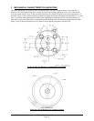
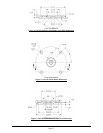


190-00879-08 GPS 18x Technical Specifications Rev. D
Page 18
4.2.7 Recommended Minimum Specific GPS/TRANSIT Data (RMC)
$GPRMC,<1>,<2>,<3>,<4>,<5>,<6>,<7>,<8>,<9>,<10>,<11>,<12>*hh<CR><LF>
<1>
UTC time of position fix, hhmmss format for GPS 18x PC/LVC;
hhmmss.s format for GPS 18x-5Hz
<2>
Status, A = Valid position, V = NAV receiver warning
<3>
Latitude, ddmm.mmmm format for GPS 18x PC/LVC; ddmm.mmmmm format for GPS 18x-
5Hz (leading zeros must be transmitted)
<4>
Latitude hemisphere, N or S
<5>
Longitude, dddmm.mmmm format for GPS 18x PC/LVC; dddmm.mmmmm format for GPS
18x-5Hz (leading zeros must be transmitted)
<6>
Longitude hemisphere, E or W
<7>
Speed over ground, GPS 18x PC and LVC: 000.0 to 999.9 knots, GPS 18x-5Hz: 000.00 to
999.99 knots (leading zeros will be transmitted)
<8>
Course over ground, 000.0 to 359.9 degrees, true (leading zeros will be transmitted)
<9>
UTC date of position fix, ddmmyy format
<10>
Magnetic variation, 000.0 to 180.0 degrees (leading zeros will be transmitted)
<11>
Magnetic variation direction, E or W (westerly variation adds to true course)
<12>
Mode indicator (only output if NMEA 0183 version 2.30 active), A = Autonomous,
D = Differential, E = Estimated, N = Data not valid
4.2.8 Track Made Good and Ground Speed (VTG)
$GPVTG,<1>,T,<2>,M,<3>,N,<4>,K,<5>*hh<CR><LF>
<1>
True course over ground, GPS 18x PC and LVC: 000 to 359 degrees, GPS 18x-5Hz: 000.0 to
359.9 degrees(leading zeros will be transmitted)
<2> Magnetic course over ground, 000 to 359 degrees, GPS 18x-5Hz: 000.0 to 359.9
degrees(leading zeros will be transmitted)
<3> Speed over ground, GPS 18x PC and LVC: 000.0 to 999.9 knots, GPS 18x-5Hz: 000.00 to
999.99 knots (leading zeros will be transmitted)
<4> Speed over ground, GPS 18x PC and LVC: 0000.0 to 1851.8 kilometers per hour, GPS 18x-
5Hz: 0000.00 to 1851.89 (leading zeros will be transmitted)
<5> Mode indicator (only output if NMEA 0183 version 2.30 active), A = Autonomous,
D = Differential, E = Estimated, N = Data not valid
4.2.9 Geographic Position (GLL)
$GPGLL,<1>,<2>,<3>,<4>,<5>,<6>,<7>*hh<CR><LF>
<1>
Latitude, ddmm.mmmm format for GPS 18x PC/LVC; ddmm.mmmmm format for GPS 18x-
5Hz (leading zeros must be transmitted)
<2>
Latitude hemisphere, N or S
<3> Longitude, dddmm.mmmm format for GPS 18x PC/LVC; dddmm.mmmmm format for GPS
18x-5Hz (leading zeros must be transmitted)
<4>
Longitude hemisphere, E or W
<5> UTC time of position fix, hhmmss format for GPS 18x PC/LVC; hhmmss.s format for GPS
18x-5Hz
<6>
Status, A = Valid position, V = NAV receiver warning
<7> Mode indicator (only output if NMEA 0183 version 2.30 active), A = Autonomous,
D = Differential (WAAS), E = Estimated, N = Data not valid
4.2.10 Estimated Error Information (PGRME)
$PGRME,<1>,M,<2>,M,<3>,M*hh<CR><LF>
<1>
Estimated horizontal position error (HPE), 0.0 to 999.9 meters
<2>
Estimated vertical position error (VPE), 0.0 to 999.9 meters
<3>
Estimated position error (EPE), 0.0 to 999.9 meters


Find Your Products By Category
- Photography
- Video Game
- Computer Equipment
- TV and Video
- Communications
- Automotive
- Portable Media
- Marine Equipment
- Cell Phone
- Baby
- Home Audio
- Fitness & Sports
- Power Tools
- Household Appliance
- Car Audio and Video
- Personal Care
- Kitchen Appliance
- Lawn and Garden
- Musical Instruments & Equipment
- Laundry Appliance
- Outdoor Cooking
Please Login
