
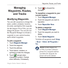
0
Owner's of the Garmin GPS Receiver Oregon gave it a score of 0 out of 5. Here's how the scores stacked up:

18 Oregon Series Owner’s Manual
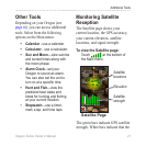
Additional Tools
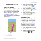
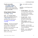
3. To display elevation data, touch a
point on the plot. The time, date,
and elevation recorded at that
point are shown.
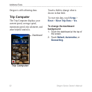
Elevation Plot Page
Data elds
Distance or
time scale
Changing the Elevation Plot
Data Fields
1. Touch Elevation Plot > one of
the data elds.
2. Touch a data type at the top of
the screen.
3. Select from the options listed
to replace the data type on the
screen.
Sharing Information
Wirelessly
The Oregon 300, 400t, 400c, 400i,
550, and 550t can wirelessly share
waypoints, routes, tracks, and
geocaches with another wireless
enabled Garmin recreational
handheld.
1. Place the units within 10 feet (3
meters) of each other.
2. On the Main menu of both units,
touch Share Wirelessly.
3. On the receiving unit, touch
Receive. The receiving unit
indicates when it is ready to
receive data.
4. On the sending unit, touch
Send.
5. On the sending unit, touch the
category of data to send.


Find Your Products By Category
- Photography
- Video Game
- Computer Equipment
- TV and Video
- Communications
- Automotive
- Portable Media
- Marine Equipment
- Cell Phone
- Baby
- Home Audio
- Fitness & Sports
- Power Tools
- Household Appliance
- Car Audio and Video
- Personal Care
- Kitchen Appliance
- Lawn and Garden
- Musical Instruments & Equipment
- Laundry Appliance
- Outdoor Cooking
Please Login
