
0
Owner's of the Garmin GPS Receiver Garmin GPS Receiver gave it a score of 0 out of 5. Here's how the scores stacked up:
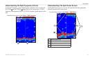

Conguring the Chartplotter
48 GPSMAP 400/500 Series Owner’s Manual
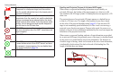
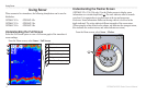
1. Dock your boat or drop anchor.
2. From the Home screen, select > > >
e > > .
3. From Home screen, select > .
4. Select a waypoint for a destination that you have navigated to previously.
5. Select > .
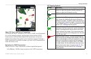
6. Review the placement of the Auto Guidance line. Determine whether the
line safely avoids known obstacles, and whether the turns enable efcient
travel.
7. Complete an action:
• If the placement of the Auto Guidance line is satisfactory, select
> > . Proceed to step 11.
• If the Auto Guidance line is too close to known obstacles, from the
Home screen, select > > >
> > .
• If the turns in the Auto Guidance line are too wide, from the Home
screen, select > > >
> > .
8. If you selected or in step 7, review the placement of the Auto
Guidance line. Determine whether the line safely avoids known obstacles,
and whether the turns enable efcient travel.
9. Complete an action:
• If the placement of the Auto Guidance line is satisfactory, select
> > . Proceed to step 11.
• If the Auto Guidance line is too close to known obstacles, from the
Home screen, select > > >
> > .
• If the turns in the Auto Guidance line are too wide, from the Home
screen, select > > >
> > .
10. If you selected or in step 9, review the placement of
the Auto Guidance line. Determine whether the line safely avoids known
obstacles, and whether the turns enable efcient travel.
11. Repeat steps 1-10 at least once more, using a different destination each
time, until you are familiar with the functionality of the Shoreline Distance
setting.
To change the communications settings from the Home screen, select
> .
—congures the input/output format for serial port 1 to use when
connecting your chartplotter to external NMEA devices, a computer, or other
Garmin devices.
• —supports the input or output of Garmin-
proprietary data for communicating with Garmin software.
• —supports the input or output of standard NMEA 0183
data, DSC, and sonar NMEA input support for the DPT, MTW, and VHW
sentences.


Find Your Products By Category
- Photography
- Video Game
- Computer Equipment
- TV and Video
- Communications
- Automotive
- Portable Media
- Marine Equipment
- Cell Phone
- Baby
- Home Audio
- Fitness & Sports
- Power Tools
- Household Appliance
- Car Audio and Video
- Personal Care
- Kitchen Appliance
- Lawn and Garden
- Musical Instruments & Equipment
- Laundry Appliance
- Outdoor Cooking
Please Login
