
0
Owner's of the Garmin GPS Receiver Garmin GPS Receiver gave it a score of 0 out of 5. Here's how the scores stacked up:

Conguring the Chartplotter
GPSMAP 400/500 Series Owner’s Manual 47
—change the coordinate system in which the map is structured.
Do not change the map datum unless you are using a map or chart that
species a different map datum.
—set the time options.
• —select , , or time format.
• —set the time zone you want displayed for time readings. If
is selected for the Time Zone, the DST option is not available and is
automatically set to .
• (Daylight Saving Time)—select , , or . The auto setting
automatically turns daylight saving time on or off, depending on the time
of year.
• —specify the reference time (from 30 minutes to 24
hours) used to calculate the barometric pressure trend. The trend is
displayed on the wind gauge when ground wind is selected (page 35) or on
the Cruising data bar (page 9).
To change the system language, from the Home screen, select >
> . Select the language.
To change navigation preferences, from the Home screen, select
> > .
—for saved routes, this determines whether route turns are
indicated by number (Turn 1, Turn 2, and so on) or by waypoint name, or
whether the description of turns is hidden.
—set how much time or how far before a turn in a route that
you transition to the next leg.
—specify the sensor used for wind numbers and fuel economy.
Select or to toggle between water (from a water-speed
sensor) and GPS (from the calculated GPS speed).
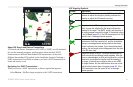
—set the automatic guidance parameters:
• —set the minimum depth (chart depth datum) to allow when
calculating an automatic guidance path. A safe depth of less than one meter
is not allowed when using automatic guidance.
• —set the minimum height (chart height datum) of a bridge that
your boat can safely travel under.
• —set the safe distance for your boat from the shore:
, , , , or .
The Shoreline Distance setting indicates how close to the shore you want the
auto-guidance line to be placed. The auto-guidance line may move if you
change this setting while navigating.
The available values for the Shoreline Distance setting (, ,
, , or ) are relative, not absolute. To ensure that the auto-
guidance line is placed an appropriate distance from shore, you can assess the
placement of the auto-guidance line using one or more familiar destinations
that require navigation through a narrow waterway.


Find Your Products By Category
- Photography
- Video Game
- Computer Equipment
- TV and Video
- Communications
- Automotive
- Portable Media
- Marine Equipment
- Cell Phone
- Baby
- Home Audio
- Fitness & Sports
- Power Tools
- Household Appliance
- Car Audio and Video
- Personal Care
- Kitchen Appliance
- Lawn and Garden
- Musical Instruments & Equipment
- Laundry Appliance
- Outdoor Cooking
Please Login
